Introduction
Jacks Hill is situated on the edge of the Wag Water Belt to the east of Kingston, with much of Kingston sited on the Liguanea Plain. With the expansion of Kingston, the area around Jacks Hill is increasingly seeing the development of housing, yet this area is geologically complex and there is rightly a concern about how this area is developed. This report explains the current understanding of the geology of the area around Jacks Hill, and the potential geological problems that relate to the area. The data used are taken from my own geological mapping of the area, and work by the Earthquake Unit (EQU) at the University of the West Indies (Mona, Kinston, Jamaica).
A simple geological history of Jamaica
The oldest rocks in Jamaica date back about 140 million years, and Jamaica (or different parts of Jamaica) have always been close to the northern boundary of the Caribbean Plate. This means that throughout its history Jamaica has always been a tectonically active island. That means it will always have experienced earthquakes, with some parts of the island being uplifted and other parts being down-faulted.
It is useful to have a simple model for the evolution of Jamaica, and a four-step model is probably the easiest to use as set out by Gren Draper. Although we say 'four-step', there is a significant degree of overlap of the steps, but all of them are relevant to understanding the geology of the area around Jacks Hill.
Phase 1: Island arc phase. From 140 million years ago to about 60 million years ago most of Jamaica was part of a volcanic island arc. We can look toward the Lesser Antilles in the eastern Caribbean as a modern example of what Jamaica would have looked like at the time. Oceanic crust was subducted underneath Jamaica and this resulted in volcanism. So we can think of Jamaica at the time as consisting of a series of volcanic islands separated by deep-water basins. Extensive suites of igneous rocks (basalts, andesites, granodiorites) were produced at this time, and some of these can be seen in the Jacks Hill area.
Phase 2: Rifting. Although much of Jamaica formed in an island arc, other parts (the eastern Blue Mountains) formed in quite distant settings (associated with mantle plumes - see the Geology of Jamaica section on this website), and in the latest Cretaceous to early Paleogene (from 70 to 40 million years ago) strike-slip (transcurrent) faulting assembled these different units into a 'Proto-Jamaica'. These strike-slip faults also resulted in the formation of rift basins (rapidly subsiding basins) that accumulated very thick successions of sedimentary (and igneous) rocks. With regards to the Jacks Hill area, the Wag Water Trough or Rift is important and has a sedimentary fill that has been estimated at more than 9 km thick.
Phase 3: Platforms and troughs. At about 40 million years ago the northern Caribbean Plate docked with North America and a change in plate motions took place. This resulted in an end to volcanism in Jamaica, and the onset of a time of carbonate production. This was a time of general extension across the island. We can look to the Bahamas as a modern example, shallow-water carbonate banks separated by deep-water channels. This was the time when the thick deposits of the White Limestone of Jamaica were formed. Shallow-water deposits were formed on the blocks (e.g., the Clarendon Block) whereas deep-water deposits accumulated in the rifts/troughs (Wag Water Trough).
Phase 4: Uplift. Around about 12 million years ago things changed. The general extension that had dominated during the formation of the White Limestone changed to one of compression. This was due to new interactions between the Caribbean Plate and the North American Plate. As a consequence, new faults formed and older faults were reactivated, and Jamaica rose out of the Caribbean Sea to become the island that we know today. Yet while this created a new island, it also brought the continued threat of earthquakes, a threat that is still wit us today.
Geology of the area around Jacks Hill
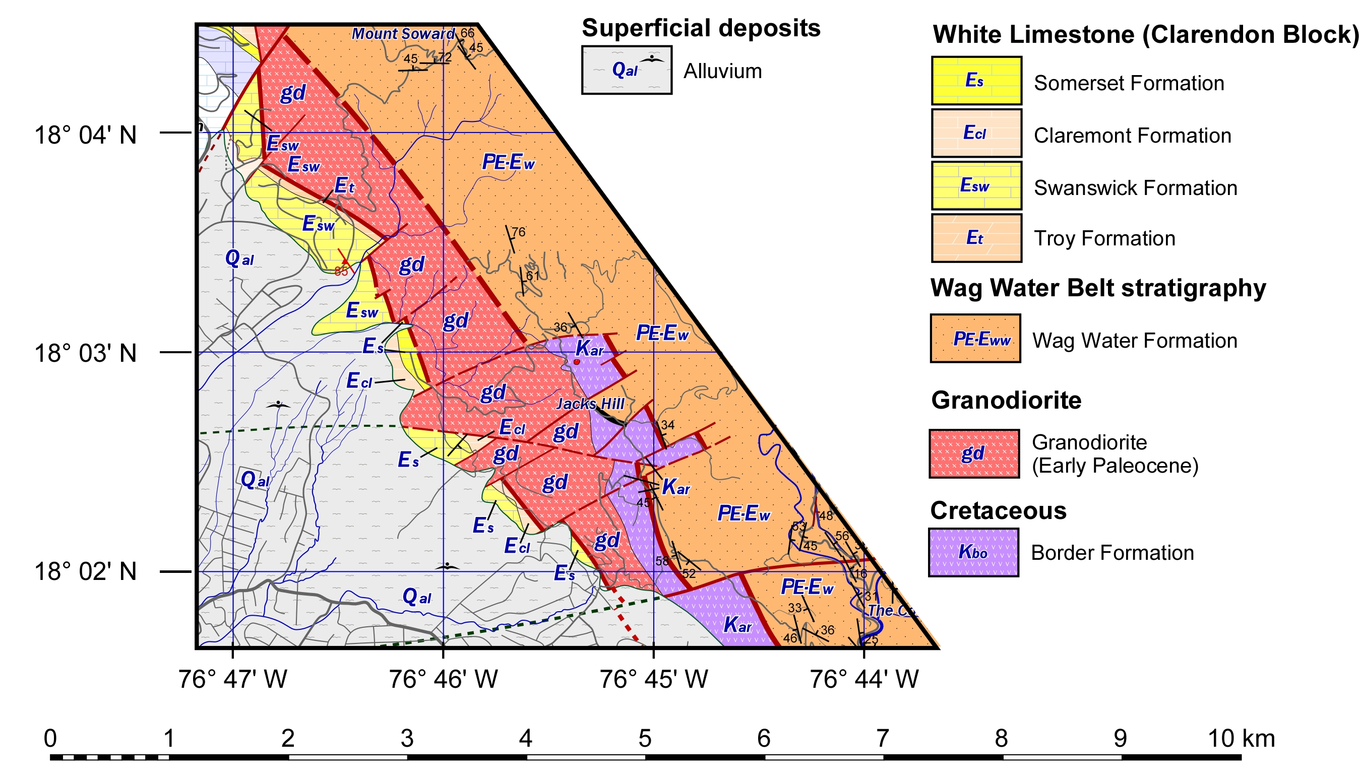
The Jacks Hill escarpment forms the boundary between the lowlands of the Liguanea Plain and the mountaneous regions of the Wag Water Belt. This boundary is represented by the Wag Water Fault Zone.
Cretaceous rocks. The oldest rocks in this area are of Cretaceous age and occur in fault-bounded strips along the Wag Water Fault Zone. The name Border Formation is used for these rocks (borrowed from the Above Rocks area). The rocks consist of lava flows and associated sedimentary rocks (conglomerates and breccias derived from the lavas), although some of the rocks could be sills. The rocks contain crystals, typically 1 mm or so in size of the minerals plagioclase and hornblende that are set in a fine-grained matrix. These are typical of lava flows. The rocks have not been dated, but by comparison with the Above Rocks area are probably of late Cretaceous (late Campanian to early Maastrichtian) age.
Intrusive rocks. The rocks of the Border Formation have been intruded by a series of granodiorites. These are coarse-grained igneous rocks, typically with interlocking crystals with sizes of 3 to 5 mm. The rocks contain feldspar, quartz and mafic minerals (typically hornblende and some biotite). These have not been dated, but similar granodiorites in the Above Rocks Inlier are of very early Paleocene age (c. 64 million years old).
Wag Water Formation. To the north-east of the Wag Water Fault Zone, rocks belonging to the Wag Water Formation are exposed. [Note that there could be further faults in this area, but these cannot be mapped due to the lack of contrasting rock types.] The Wag Water Formation consists of reddish or purple sandstones and conglomerates. It is part of the fill of the Wag Water Trough.
White Limestone. Various formations of the White Limestone form a narrow belt on the Liguanea Plain side of the escarpment. These rocks include the Troy, Swanswick, Claremont and Somerset formations. These rocks lie within the Wag Water Fault Zone and many are extensively brecciated.
Liguanea fan deposits (alluvium). Kingston is largely built on a series of conglomerates that were deposited by the Hope River prior to its capture (it formerly would have flowed across the Liguanea Plain, but now flows through August Town). These deposits mask the south-western margin of the Wag Water Fault Zone.
Structural geology
The Wag Water Fault Zone is a 1.5 to 2.5 km wide zone that brings up Cretaceous rocks and rocks belonging to the White Limestone Group in front of the uplifted Wag Water Belt. The rocks in this zone are liable to be deformed and breciated and offer problems in terms of slope stability.
Weathering. The warm wet climate of the tropics leads to deep weathering of rocks. This is particularly true of igneous rocks. The original mineralogies of these rocks are altered to clay minerals, and as a result a thick regolith (weathered rock) profile is developed. Such regoliths in Jamaica are typically 20 to 30 m thick, but are probably much thicker in fault zones. Regolith results in rocks that are unstable and steep road cuts through such rocks are liable to failure. Cutting roads into slopes will result in landslides.